Special Event

BPNThe Better Planning Network is holding a special event on Origin night this week. Hopefully there will be a summary of what was said.
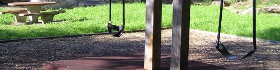
 

A REMINDER:  Special event at Parliament, Wednesday, 1 June at 6pm.

In 2011, the Coalition government came into power on the promise of returning planning to local communities. However since then the government has steadfastly introduced changes that fast-track development and dilute community engagement. In addition, the government has established the Greater Sydney Commission and more recently made changes to local government.

In response, we invite you to join us at the next BPN Planning Event, when we hear Sarah Hill, the new CEO at the Greater Sydney Commission’s, explain their role and how community engagement will be managed.  We have also invited a panel of eminent experts to join Ms Hill for a panel discussion, with the opportunity for questions from the audience.

In addition, the Minister and executive staff from the Department of Planning have been invited to attend the event, so they can hear the conversation.

As part of the event, Ms Hill will also discuss the commission’s work underway – including the preparation of six draft District Plans for the Greater Sydney region (previously Regional Plans). The plans are required to be exhibited by late January, 2017 with a subsequent review of Sydney’s Metropolitan plan in 2017. Once finalised, the plans are intended to inform changes to local planning controls.

We’ll also provide an update about the government’s plans to change the EP & A Act which legislation is intended to be introduced into the spring parliament. This includes a number of aspects from the Planning Bill 2013 and other amendments, however is not proposed to change the definition for Ecologically Sustainable Development (ESD).

Tickets to BPN‘s special event are free, however as seating is limited, reservations are essential. As seats are filling up fast, reserve your ticket ASAP using the eventbrite link above.

As the legislative changes also impact rural and regional areas, members and affiliate groups outside the Sydney basin are also invited to attend. We look forward to seeing you.

Upgrade of Greville St Reserve

OLYMPUS DIGITAL CAMERA

Have your say

The Greville Street Reserve (near the Church of Scientology) due for a makeover. Council is calling for your views, comments and suggestions.

You can undertake the quick survey at www.haveoursaywilloughby.com.au or sent an email (attention Meredith Paterson via: email@willoughby.nsw.gov.au

Closing date for suggestions is 8am Monday 20th June 2016.

If you have any questions, ring Council on 9777 1000


Illuminated signs -Boundary Road

There is a DA application that the Department of Planning has put forward as part of ‘Major Projects’ that closes this Monday to turn the two large advertising signs under the Boundary St Railway Bridge digital.

It looks like only RMS has made a submission yet and that neither Willoughby or Ku-ring-gai Council have made one yet (I have emailed our West Ward and Middle Harbour Councillors this afternoon).

The RMS submission, which opposes the sign on one side, also looks like it was made by someone who was at their desk and doesn’t know intimately how that whole section of road operates at present like we locals do, and consider all the safety issues with this intersection and how dangerous it would be to create an additional distraction right at this already complicated traffic location.

I know there is lots happening but it would be good if our Progress Associations or individual members could put in submissions, even if just a quick sentence re the related safety issues to ensure that there is proper representation on the issue. I am concerned to ensure that because it is on the boundary of two council areas and the boundary of two progress associations and made at a time when people are focussed on the amalgamations that  it does not get missed by all. If you consider that there are safety issues can you please put in a submission on behalf of the Progress Associations and/or as individuals by the closing date on Monday.

It is quick and easy to make an electronic submission at the following link (the Railbridge DA is second down on the list) or go to Dept of Planning website and ‘major projects’ and put in ‘Willoughy’:

http://majorprojects.planning.nsw.gov.au/index.pl?action=search&page_id=&search=&authority_id=569&search_site_type_id=&reference_table=&status_id=&decider=&from_date=&to_date=&x=58&y=12

To give you a summary of some of the issues, here is a copy of my submission:

Digital signs can be very distracting and it is very dangerous to have digital signs distracting drivers within a major intersection. These applications to replace the existing signage with digital signage should be refused because they pose a serious road safety issue for the following reasons:

  1. The section of Boundary Street from the Pacific Highway to Archer Street is very busy and currently operates like one big intersection for much of the day, and should be treated as such for consideration of this DA application.
  2. This is already quite a dangerous section of road because:
  • there is already much confusion and distraction with traffic entering this section from Hill Street and Archer Street, and because of the volume of traffic quite a few cars fly out of Hill street unexpectedly and in traffic gaps that are too narrow to accommodate them;
  • there are cars changing lanes right where the digital signage is proposed in both directions as  the numbers of lanes increase in both directions within metres of the proposed digital signage;
  • this is the major thoroughfare from the Northern Beaches through to the Ryde area and Western Sydney, and many drivers who come through are new to the area and don’t know which way to go and need to make last minute decisions which lane they need to be in.
  1. In this section of Boundary Street the drivers changing lanes, those turning into Boundary St and those already in Boundary St need to be fully focussed on the road, other drivers, and what else is happening ahead of them in this large 3 in 1 intersection (which combines 3 intersections which are each busy intersections in their own right); and
  2. The existing non-digital signage which has been put in place since the Bridge was replaced is already a enough of a distraction.
  3. There are also cars coming in and out of the petrol station driveway and in the driveway to the units on the South and the North Side of Boundary St between the highway and the Bridge, and drivers don’t usually expect cars to be turning in and out of these driveways.

For these safety reasons the application to convert both signs to digital signage should be refused.

In considering road safety data for this application, Boundary St is the boundary between two Council areas, so you need to acquire the data for both Kuringgai and Willoughby because some accidents are recorded by police as being in one Council area and some in the other, and without both sets of data any figures you use will be materially understated. (This was the case when accident rates at the Boundary St/Spearman St intersection were being considered, and it was not showing up as being a dangerous intersection because data was being attributed to two different council areas. When data was considered together it was realised there were issues)”


Amalgamation Court Case

AmalgamationFight

From Council:

Land and Environment Court joins

Willoughby Council into Mosman and North Sydney legal proceedings

The Land and Environment Court yesterday (Thursday 26 May) joined Willoughby Council into Mosman Council and North Sydney Councils’ legal proceedings against the State Government regarding proposed Council mergers.

Willoughby Council’s lawyers appeared on behalf of Council in the Land & Environment Court to present Council’s resolution that they did not wish to be joined to the proceedings of either Mosman or North Sydney.

His Honour Justice Moore indicated he would join Willoughby Council as a party, giving Council the right to file a submitting appearance and take no active part in the proceedings.

Council will now serve a submitting appearance save as to costs. This allows Council to be joined to the proceedings as an observer while being largely protected from costs.

This follows a Willoughby Council meeting on Monday 23 May where Council resolved not to join proceedings led by Mosman and North Sydney Councils, after considering two pieces of correspondence:

  • a Notice of Motion in proceedings no. 40395 of 2016, Mosman Council v Minister for Local Government (the Mosman proceedings). The Mosman proceedings attached a Notice of Motion seeking to join Willoughby; and
  • A letter from Matthews Folbigg dated 20 May 2016, North Sydney Council v Minister for Local Government (the North Sydney proceedings). This letter suggested that the Council should be a party to the proceedings.

– Ends –

On the right track?

WilloughbyCouncilLogoThe financial report by Council below on the surface sounds good. However, it behooves that some of the information be closely scrutinised.

It is good to note that Council’s apparent new focus on a long awaited Project Management focus is paying dividends.

However, we should ask if it is in the community’s interest to reduce spending on projects as indicated below. Council is there to provide community resources.

By its nature, Council is not in the business of making profits (surplus). If they were we should see some of our rates refunded.

So, whilst this report is generally positive it does beg some questions.

Willoughby well on track

Third quarter report indicates surplus finances and project milestones met

Willoughby Council’s third quarter report (1 Jan – 31 Mar 2016) of its 2015/16 Operational Plan and Financial Performance provides for a further surplus movement of $2.239M, confirming Council’s current strong operating and financial position (estimated annual operating position of a $4.928M surplus).

This positive result is linked to a reduction in anticipated expenditure of a net $1.881M, linked to savings in anticipated employee costs of $612K, and materials and contracts of $1.458M. An increase in income of $358K from additional funds largely from hoarding fees and interest on investments, also contributes to the positive result.

The report, presented at last night’s Council meeting (Monday 23 May 2016), also projects council’s Unrestricted Working Funds for day to day operations to be at $3.431M net of anticipated carryovers, at the end of the Financial Year. This is an improvement of $1.549M on 2014/2015.

Other highlights of the report include the on-track status of Council’s Priority Improvement Program, with 98 per cent of all budgeted projects for the financial year either complete (69 per cent) or in progress (29 per cent) at 31 March 2016. Of all budgeted projects (not just those commenced or completed), 97 per cent have met their respective milestones.

An update on The Concourse Financial Review reveals the actual nine month result exceeds an external consultant’s estimate by a surplus of $180K. This positive results stems mainly from Paid Parking.

“The third quarter report confirms Willoughby Council is in a solid financial and operating position and provides a positive outlook for the future of our community. Council’s recent focus on working smarter and project management is paying off. This is part of Council’s commitment to continue delivering for our community, while we navigate a potential time of change,” said Willoughby Mayor, Gail Giles-Gidney.

– Ends –

Selling Chatswood Golf Club

As hasChatswood Golf Club occurred a number of times since its inception, Chatswood Golf Club is proposing to sell some of its land.

NOTE: This article is being continuously updated as new information comes to hand.

On the 6th June 2016 at 7PM the golf club is seeking their member’s approval to sell a large Chatswood Golf Course Redevelopment Plan
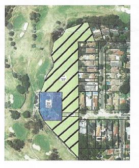
portion of their land as shown in the accompanying diagram. This land includes their carpark and clubhouse. Members have been told that the Club wants to sell the land to ‘Watermark‘ for the purpose of constructing ‘seniors living apartments‘. It also appears that as part of the development the Club would gain a new clubhouse with underground parking.

There is no information as to the scale and density of the new residential development. This would be subject to a separate development proposal. With the pending dismissal of Willoughby Council, it is unclear as to who would assess such an application.

Details about the proposal can be found at Briefing 6  and Notice of Meeting

The proposed development is likely to pose a number of concerns for nearby residents including: increased traffic in Beaconsfield Rd; overlooking onto residential properties and loss of privacy and other impacts.

THE CLUBS HISTORY OF SELLING OFF ITS LAND

In preparation


Lane Cove ‘Rat-Run’

Residents in Dalrymple Avenue are concerned about traffic changes that Lane Cove Council may make. What happens with traffic in Lane Cove impacts Willoughby residents.

“I find it amazing how Lane Cove Council are considering implementing changes that will have more impact on the West Ward residents; streets were built for vehicles and I dont believe traffic restrictions should be implemented just because residents dont like the increased traffic.  The proposed changes at Karilla Avenue Lane Cove will impact on West Ward residents especially since we are still only permitted to turn left at the Beaconsfield road lights”.

Kind regards,

 Resident
Dalrymple Avenue
Lane Cove North

Some years ago when local Councils had control over traffic, Lane Cove Council implemented traffic changes to benefit their residents. These changes had widespread impact. Such was the impact that the then RTA removed Council’s control over traffic. Since then we have all been at the whim of RTA/RMS decisions.

You can read below the North Shore Times take on this matter.

“A GROUP of residents forced to “bear the brunt” of a daily “stampede” of speeding traffic caused by a twoway rat run has called on Lane Cove Council to act.

The frustrated residents – living on a network of streets being used as a thoroughfare between Centennial Ave and Epping Rd – claim council has neglected their pleas for a number of years now, despite the problem increasing “exponentially” with the suburb’s blossoming development.

The residents said vehicles used Karilla Ave, Parklands Ave and Kurri St to bypass traffic at peak times, creating a convoy of speeding vehicles through the narrow residential streets.

“The residents of Karilla Ave are being unfairly affected by council inaction over several years,” resident Jon Johannsen of Karilla Ave said at a council meeting last week.

“(There’s a) noticeable growth in the glitzier vehicles with augmented muffler systems, loud music and a tendency to use Karilla as a speed test zone.

“This means faster speeds up to 70km/h in some cases occur with single vehicles in either direction and that’s when they’re not travelling in convoy, which we regularly get.”

Karilla Ave resident Ruth Neumann said: “We bear the brunt of the two-way rat run on a daily basis. We experience the growing intensity of the rat run travelling both east and west.

“We are concerned at the increasing volume, speed and safety issues.”

The residents are lobbying the council to amend traffic rules to allow only left-hand turns from Karilla Ave into Centennial Ave and no entry into Karilla Ave from Centennial Ave.

Ms Neumann argued that the council had taken such action on surrounding roads, so Karilla Ave should be included or those streets opened up to distribute the rat run equitably.

After the meeting, Ms Neumann told the North

Shore Times many residents felt frustrated and neglected after campaigning the issue with council for more than four years without results.

“This has been a longstanding issue that the residents’ association has tried to engage with council on,” she said. “It is increasing exponentially. As they open up more and more apartments we seem to be getting more and more vehicles.”

Lane Cove North Residents’ Association president June Hesseran said the problem was making it “very dangerous” for residents to come and go from their driveways.

“These people are only interested in getting from A to B in the fastest possible time and they think it’s their God-given right,” she said.

“I have got to the point now where I try not to leave the area before 9am in the morning. Somebody is going to be badly injured or even killed,” Ms Hesseran said.

A council spokeswoman said the matter would be addressed this week at the Lane Cove North Advisory Committee to discuss the results of a recent traffic consultation. From there, a recommendation would be made to the council’s traffic committee, she said.

The residents of Karilla Ave are being unfairly affected by council inaction Resident Jon Johannsen”.

Metro Southwest EIS Analysis

The Environmental Impact Statement (EIS) Summary covering the Chatswood area is now available. It raises a number of questions and the opportunity for comments. We are seeking feedback on these issues from West Ward residents.

WHAT IS THE SYDNEY METRO SOUTHWEST?

The new METROs (NORTH & SOUTH WEST) are (for Sydney) a new form of transport. Metros are driverless trains operating every few minutes. Existing TransportNSW rail lines need to be modified to allow Metros to operate. This means that standard rolling stock can longer use these line (including from Chatswood to Epping).

Metro trains will arrive at Chatswood Station from Epping (and beyond) and then continue toward the city via a ‘dive site’ into a tunnel with new stations at Crows Nest, Victoria Cross (North Sydney), Barangaroo, Martin Place, Pitt Street, Central on to the southwest.

ISSUES

The issues are presented in the order of the EIS. The order does not imply relevance or seriousness.

DO WE NEED A METRO?

The EIS assumes that the Metro is a fait accompli (and it probably is). However, the opportunity exists to comment generally on this issue.

INTEGRATING THE METRO IN SYDNEY’S TRANSPORT NETWORK

For many years, Sydney’s transport network consisted predominately of heavy rail trains and buses. Even then, achieving effective interchanges between the two modes was difficult. Now, in addition, we have the Sydney Light Rail and the new Metro network. This increases the complexity of interchanges.

We will advocate that intense consideration be given to minimize time taken at interchanges.

OVERSTATION DEVELOPMENT

 The EIS proposes development above the new stations. However, Chatswood is not mentioned. Since such development is subject to a separate planning approval process, this does not preclude future over station/line development within West Ward. Apart from over Chatswood Station, there is possibility that the tunnel construction site at the intersection of Pacific Highway and Mowbray Rd could also be slated for development.

 We should formalize our position on development at these two location!!!

POWERING THE METRO

The decision of where the new electricity cable to power the Metro should run is separate to issues canvassed in this EIS.

TUNNEL BORING MACHINES

Operational access to the site will be via Nelson St.

PROPERTY ACQUISITION

The site bounded by Mowbray Road, railway line, Nelson St and the Pacific Highway is being acquired as the western construction site. This is where the tunneling begins.

The Nelson St Bridge is to be removed (and not replaced).

 Why is the bridge being removed? Why cannot the bridge be re-installed?

 Has a traffic study been undertaking on the impact. What was the outcome?

 TRAFFIC MATTERS & HAUL ROUTES

New right-hand turn on Pacific Highway:

The removal of the Nelson St Bridge will result in the need for right turn lanes (south-bound) for traffic needing to get onto Mowbray Rd West. Originally there was talk of two right turn lanes. The EIS mentions just a single lane.

What is our position on this proposal?

Ingress/Egress to the construction site: Access to the site will be from Nelson Street and Mowbray Rd. Egress will be from Mowbray Rd. Spoil haul trucks will need to turn right onto Mowbray Rd then right at the Pacific Highway. So you can envision the chaos with traffic controllers stopping traffic on Mowbray Rd to allow trucks to exit.

 What is the destination for spoil?

 Could an alternate haul rout be considered that does not require trucks to cross Mowbray Rd?

 Mowbray Rd & Pacific Highway

Due to the removal of the Nelson St Bridge, It is proposed to install a right hand turn for Pacific Highway traffic southbound into Mowbray Rd West. Previously the plan was to install two right-turn lanes.

Is this proposal supported?

 Is the preference for one or two right turn lanes?

 Hamden Road & Mowbray Rd.

Proposal for new traffic lights

 Supported?

 Orchard Road & Mowbray Rd.

Proposed change to phasing of lights.

What do the changes entail?

 NOISE AND VIBRATION

There will be noise barriers along the rail corridor (Why?).

Existing noise barriers will be increased in height to about 4 metres Chapman Avenue/Nelson St, Frank Channon Walk, Nelson/Gordon Sts. A 2 metre barrier will also be built to the south of Mowbray Rd on the western side of the line.

Should noise barriers be installed at other sides of the site such as Nelson St and the Pacific Highway?

OPERATIONAL MATTERS

Demolition & excavation

Monday to Friday 7AM to 6 PM & Saturday 8AM to 1 PM. All other work 24 hours a day.

Are we OK with proposed hours?

 What type of 24 hr work might pose a nuisance?

 Truck movements

Demolition: 96 per day plus 78 light vehicles

Excavation: 234 per fay plus 248 light vehicles

Tunnel excavation: 286 per day and 248 light vehicles

Tunnel fit out: 254 per day and 248 light vehicles

It is claimed that spoil removal by freight train is not feasible as the T! North Shore line is not currently rated for freight transport.

Consideration should be given to upgrading the T1 line to freight capability.

Please refer elsewhere about our request to alter right turn egress from the site onto Mowbray Rd.

Can we please be provided with some comparative information to allow us to understand the potential impact of these movements?

 HERITAGE ASSESSMENT

MetroEISHeritageThe heritage-listed Mowbray House School site is shown (hatched) on the construction site diagram. It is proposedto retain the building. However, archival recording and reporting will be undertaken before works starts

Mowbray House: Direct impact: Minor (physical impact). 􀂃 Potential direct impact: Minor (vibration) – the closest façade of this item would experience vibration above the 7.5mm/s screening level for cosmetic damage. 􀂃 Indirect impact: Minor (views and vistas)

 What steps will be taken to protect the building from potential vibration damage?

 What guarantee is given that, if damaged, the building will be repaired?

 Can a copy of the report on Mowbray House be given to the Willoughby/Lower North Shore Council and the Willoughby District Historical Society?

 It is reported that the heritage sites such as the Great Northern Hotel, the Garden of Remebrance, the Water Tanks, the South Uniting Church the Electricity Sub-station and the house on the eastern side of the line will mainly suffer from visual impacts.

OTHER MATTERS

 Frank Channon Walk

It is proposed to extend Frank Channon Walk to Mowbray Road. During construction, there will be short-term (weekend closures).

Trees

Trees will be removed within the rail corridor between Nelson St and Mowbray Rd.

Why can’t a 2 for 1 tree replacement process be implemented across all work areas?

 Onsite parking

Provision for 300 cars (but only predicting 248 movements per day).

The estimates for movements appears to be understated and should be reviewed.

 It is reported that contractors MAY CONSIDER ‘park & shuttle’ services to transfer workers to and from the site.

Problems (particularly parking) with site workers occur on every major construction site. Parking arrangements for workers and contractors should be implemented as a Condition of Consent.

 Bus stops

Temporary re-location of the 575 bus stop on Pacific Highway (between Bryson and Mowbray Rds)

 Clarify current and proposed locations.

 RELATED PROJECTS

 METRO NORTWEST

Issues relating to the temporary closure of the Chatswood to Epping rail line and replacement of train services by buses during the construction period.

Issues relating to potential overcrowding on Chatswood station if the Southwest Metro does not proceed.

Power Transmission cable

Route between Artarmon and Chatswood north