 The Greater Sydney Commission has been tasked with developing something new – District Plans that connect local planning with longer-term regional planning for Greater Sydney. It’s a big picture approach to better coordinate State and local government planning.
The Association has been asked to contribute to this conversation. The President and two Vice-Presidents will attend a planning session next Monday. Following are some thoughts on some of the issues we face in our area. Additional viewpoint appear in the Comment Post to this article.
Please contribute your own comments using the Comments box below.
Greater Sydney Commission – Community aspirations
COMMUNITY CONSULTATION
Must be meaningful
Meaningful community consultation must begin very soon after a project’s inauguration and continue throughout the ongoing stages of the project process.
Local consultation
As a geographer, I take umbrage to your use of the term ‘District Plans’ Your districts are at the regional level. So the ‘Northern Region’ consists of perhaps four sub-regions (Hornsby/Kuringai); Lower North Shore (Willoughby, North Sydney. Mosman); Northern Beaches; (Hunters Hill, Lane Cove, Ryde). Within each sub-region there are districts and within the districts, precincts.
One can only assume that the focus on a region is financially motivated. This is not the best geographic area to undertake consultation. In fact, it appears that most of the Commission’s consultation is occurring at a ‘whole of Sydney’ level.
The Commission must develop meaningful consultation models at a local level.
JOBS
Protection of employment opportunities
Willoughby LEP 5 made provision for employment zones (particularly on the western side of Chatswood Station. However, in the past few years, government agencies such as JRPP. PAC and others have allowed the use of designated employment areas for residential development. These areas need to be sustained.
Industrial land
Zoned industrial land at Artarmon and East Chatswood have been eroded by allowing retailing within the industrial zone. There may be some sense in allowing retailing within these zones, but at the same time the gross capacity of the industrial zone should not be eroded. There needs to be a study undertaken of how the light industrial usages of the zone can be encouraged (perhaps by fostering higher rise facilities for some industries such as printing, car repair and detailing and others.
HOUSING AN INCREASING POPULATION
Faire expectations
A key aspect of housing an increased population is that catering for the increase needs to be geographically (and politically) spread. All districts, regions and sub-regions should bear equal responsibilities to cater for growth
Consistent application
Under previous attempts of ‘urban consolidation initiatives, many Councils’ dragged the chain’ only to have state instrumentalities take over their planning powers. Most of the results have been disastrous (for example in Lane Cove and Kurringai). A new planning regime must ensure that local communities bear their responsibilities and move toward the achievement of a common goal across the city.
Reconsideration of ‘Inner Ring; ‘Central Ring’ and ‘Outer Ring’ strategies
In the past, based on an argument of the cost of infrastructure, a relatively large burden of housing an increasing population was forced on inner and central ring communities. Such an approach is inequitable. We call on the Commission to ensure that the pain of housing an increased population is shared across the city; At the same time, we encourage the Commission to argue a case to the State Government for a Housing De-centralisation Policy.
TRAFFIC
Installation of east bound ramps from the F1 onto the M2.
Traffic from the Central Coast heading for Sydney is directed to the Pacific Highway which is at capacity at many intersections. The installation of ramps will alleviate congestion on the Pacific Highway btween Round Corner and the City.
Grade separated intersections at Fullers Rd and Mowbray Rd
Both these intersections are overcapacity for large parts of the day (CAT F). The use of grade separation will alleviate this congestion.
Road hierarchy
Regulating the traffic hierarchy of local, collector, regional, state and national transport routes with a view to providing increased residential amenity in the form of reduced traffic flows in traditional residential streets in favour of directing through traffic to uses higher order rouds.
RESIDENTIAL PROXIMITY
Professional offices in residential areas
With a view to reducing the number and length of car trips a return to historic access to professional services particularly such as medical services makes sense (remember the days when there was a red Drs. Light just around the corner?).
Access to local basic supplies
Traditionally, communities had access to a ‘local corner shop’ or ‘neighborhood shopping facilities’. Generally, such facilities have returned to the urban milieu. However, there is a noticeable lack of such resources in Chatswood, west of the Pacific Highway. Strategies to be developed to rectify the situation.
Urban linkages
Facilitating pedestrian between residences and community facilities such a transport locations, shopping and educational facilities and the like to foster well-being.
TRANSPORT
Upgrade the Chatswood and St Leonards Transport Interchanges
Both of these interchanges are performing sub-optimally. If we want people to use public transport we must provide them with safe and reliable door to door facilities (to compete with the motor vehicle). Interchanges are a key element for a cross modal system.
Return ‘light rail/tramways’ to the eastern side of Chatswood, along Victoria Avenue and Penshurst Street.
Re-introduce the ‘No Standing’ traffic sign or introduce a new sign
This sign was removed as part of the AusRoads program. Unfortunately, there is not a sign that provides the same opportunity. The No Standing sign allowed a vehicle to stop and set down passengers or good. However, the vehicle was not allowed to park in the zone (unlike the allowance with the No Parking sign. One of the greatest benefits of this sign was as the statutory provision to support ‘Kiss & Ride’ zones. Currently there is no traffic sign to undelay the Kiss and Ride.
Allow taxis and ride share operators to pick up and set down in bus zones.
Bus zones are typically allocated high priority at major transport nodes. The provision of pickup & set down within these zones fosters cross modal transport options.
PROVISION OF (AFFORDABLE) HOUSING
Code based assessment
Most people want certainty when it comes to development next to them.
SEPP 1
SEPP 1 provides flexibility in the application of planning controls operating by virtue of development standards in circumstances where strict compliance with those standards would, in any particular case, be unreasonable or unnecessary or tend to hinder the attainment of the objects specified in section 5 (a) (i) and (ii) of the Act. The authors of the SEPP have stated publicly that the intention was to allow some flexibility with up to 10% variance from code. The SEPP has been used to gain approval for variations far in excess of the stated 10%. The SEPP should be amended to restrict any sought after various to less than 10% of code.
Private Certifiers (PCs)
There are myriads of examples where PCs have approved construction not in accordance with approvals. Take the control of building compliance out of the hands of private certifiers and return it to Council staff.
Contextual concentration of residential development in association with transport nodes and corridors
In the past, Willoughby has successfully protected large swathes of traditional residential dwellings by focusing residential development within its CBDs and along transport corridoes. This approached should be maintained.
Protection of conservation and environmental living residential zones
In the past, Willoughby has successfully protected large swathes of traditional residential dwellings by the creation of Conservation zones and Environmental Living zones. This approached should be maintained.
OPEN SPACE
The overriding tenet in relation to open space is that with development the quantum of open space should increase.
Bushland
Bushland has inherent environmental, health and social value. As such, it should never be compromised. In fact, environmental programs such as Willoughby Council’s e-restore should be widespread with a view of returning degraded land to an acceptable state.
Alienation of open space
It is accepted that from time to time the use of a particular parcel of open space may need to change. However, whenever this occurs, every effort shall be made to ensure continued public access to the open space.
Public open space must never be sold. However, it is understood that public open space may be leased (again with the proviso that some form of public access is maintained to the land.
Green web
Establishing evidence-based appropriate linkages between portions of open space to support fauna, vegetation and human needs.
ALIENATION OF COMMUNITY RESOUCES
Contestability
Often there are historical circumstances that have delivered quasi exclusive use of community resources to specific (often founding) groups on more than favourable terms. This can lead to th exclusion of more recent groups attaining access to community resources. To this end, all allocations of community resources must be based on a transparent, contestable footing.
Maintaining public benefit
In instances where it is decided to alienate community resources in favour of a specific organization, terms of lease should be such that in the event that the lease derives a windfall benefit from the lease, ANY SUCH WINDFALL IS TO BE SHARED WITH Council.
EDUCATION
The provision of appropriate public schooling on the Lower North Shore has seemed problematic for the State Government for many years. We call for an independent strategic analysis of demand and supply of students places be undertaken and published.
In relation to specific infrastructure opportunities we would:
- call attention to the opportunity, post completion, of the Metro South Dive Site (intersection of Mowbray Rd & Pacific Highway) for educational usage (given the heritage of the use of the site for education)
- call for the purchase of the residential block adjacent to Chatswood Public School to allow expansion of the school’on-site’ rather than the current splitting of the school across two campuses (CPS and Chatswood High Svhool).
OTHER
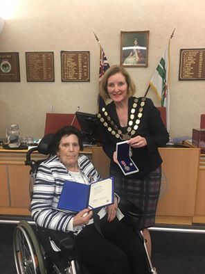 Willoughby Councillor, Mandy Stevens was presented with an Outstanding Service Award at


