
The memorial is at The Councourse, just down from the Box Office entrance opposite the water feature.
Former Mayoress Beth and Mayorette Sophie on the left with some Pat supporters.
The memorial is at The Councourse, just down from the Box Office entrance opposite the water feature.
Former Mayoress Beth and Mayorette Sophie on the left with some Pat supporters.

The latest edition of the West Ward News goes to print next week in time to be delivered to households on the weekend before the election.
You can read an advance copy of the NEWS here: West Ward News June 2016.
This edition of the West Ward News contains articles about:
News Bytes on the:
 Did you know that the Chatswood West Ward Progress Association has a facebook site?
You can like or follow us at Facebook.com/cwwpa.org
All posts to cwwpa.org are automatically posted to Facebook. So you can just use Facebook to find out what is happening in your area.
 On 7 September 2015 Council resolved to adopt most of the recommendations of the Mowbray Road West Traffic Study.
This study was carried out by consultants PeopleTrans on behalf of Council.
One of the recommendations approved by Council was for the introduction of traffic calming measures in the form of a Local Area Traffic Management in Coolaroo Road and Dalrymple Avenue. It was noted within the Council resolution that the design of the LATM Scheme “will require considerable resident consultation, and there will be considerable cost involved to construct the devices”.
The PeopleTrans Study found that Coolaroo Road and Dalrymple Avenue are key routes for locals, but are also used as rat-runs by other drivers to avoid congestion on Mowbray Road West during the morning peak period.
In September 2015 PeopleTrans were commissioned by Council to undertake the concept design of the LATM measures on Coolaroo Road and Dalrymple Avenue. These measures were aimed at addressing the concerns of local residents regarding safety by reducing speed and aggressive driver behaviour on those roads.
On 19 November 2015 PeopleTrans conducted a workshop which was attended by two residents from Coolaroo Road and two residents from Dalrymple Avenue, as well as Council officers. The primary outcome of the workshop was to reach agreement on what the LATM scheme should achieve, and the location and type of LATM devices that should be introduced. At the meeting it was agreed that there were two main types of treatment that would be appropriate for Coolaroo Road and Dalrymple Avenue. These treatments were:
Sinusoidal road humps
One lane slow points
It was recommended that these devices need to be located such that they are not too far apart, (approx. 80m) if they are to be effective in reducing speeds along the whole street. Also, different types of devices may have varying impacts when used in combination. A sinusoidal road hump differs from a watts profile speed hump in that it has a smoother curved profile at its base where it meets the road. Therefore it is less severe when vehicles drive over it. For the one way slow points the study recommended that Give Way signs be installed so that right of way be given to traffic in one direction over the other direction. This is intended to reduce conflict issues related to right of way and improve the overall safety of the devices.For both sections of Coolaroo Road, this would mean that eastbound traffic would be required to give way to westbound traffic at the slow points. On Dalrymple Avenue northbound traffic would be required to give way to southbound traffic.
The advantages and disadvantages of the sinusoidal road humps are listed below:
Effective in reducing speeds
No loss of parking as drivers will be allowed to park their car on the road hump
Sinusoidal hump has a preferred profile for cyclists compared to watts profile or flattop
Would be cheaper to construct than one lane slow points
Some increase in noise due to vehicles driving over the device, but anticipated to be within acceptable levels
The advantages and disadvantages of the one lane slow points are also listed below:
Effective in reducing speeds
Includes a bicycle bypass lane
No increase in noise
Some loss of on-street parking (11 spaces in Coolaroo Rd west, 9 in Coolaroo Rd east, 8 in Dalrymple Ave) T
here was also a 3rd option for the section of Coolaroo Road to the west of Greenlands Road. This option involved a combination of formalised parking spaces and road narrowing. However this option would result in the loss of 53 out of 76 available on-street parking spaces in this section of Coolaroo Road, so it was not considered acceptable.
In addition to the above devices, PeopleTrans also recommended a modified T-intersection where Coolaroo Road meets Dalrymple Avenue.
The PeopleTrans report found that the LATM options provided for Coolaroo Road and Dalrymple Avenue would achieve the key objective of reducing speed to below 40km/hr and improving resident amenity in these streets. It also found that the relative difference relating to speed reduction between the road humps and the slow points was marginal. The slow points would be better from aesthetic viewpoint, due to the opportunity for landscaping and the minimal noise impacts, however this needs to be weighed up against the loss of parking for this option.
OFFICER’S RECOMMENDATION
That Council consult with residents for their views on the proposed introduction of;
1. Sinusoidal speed humps, or
2. One lane slow points, to determine a preferred option for traffic calming devices in Coolaroo Road and Dalrymple Avenue.
The Federal Labour Opposition has promised $20 million to hold plebiscites for all Councils in NSW on the issue of amalgamations. The plebiscites would be for Councils yet to be merged, plus for those already merged.
Such plebiscites would not be binding on the Baird Government, who have labelled the initiative as ‘nothing but a stunt’.
Note: If you have a question of the candidates, please email it to cwwpa.org@gmail.com by Tuesday 14th June.
Meet the Candidates – Federal seat of North Sydney & Bradfield
Tuesday, June 21 2016 7:15 PM – 9:15 PM
Dougherty Community Centre
Event arranged by the Federation of Willoughby Progress Associations Inc
The Federal election has now been called for Saturday, July 2nd, 2016.
The Federation of Willoughby Progress Associations Inc. wishes to invite all residents who reside within both the Federal electoral boundary of North Sydney and Bradfield, to a “Meet the Candidates” evening.
This session is an opportunity for all constituents to meet, listen and pose questions to each of the respective Lower House candidates. What’s in it for us? We want to know what the candidates believe in and stand for, related to any matter being asked.
The Candidates – for North Sydney
Meeting Procedure
We have almost two hours to glean the most from this opportunity.
The meeting protocol will be designed to ensure:
Agenda:
Meeting
Where: The Auditorium, Dougherty Centre, 7 Victor Street, Chatswood, NSW
When: 21st June 2016
Time: 7PM for 7:15PM start. Meeting conclusion: 9:15PM
Parking is available at the adjoining Westfield Car Park.
We look forward to seeing you there and making this evening a success.
Here are the details of candidates standing at the upcoming Federal election:


 Chatswood West Ward Progress Association (CWWPA) President Jim McCredie has stepped down as one of our delegates on the Federation of Willoughby Progress Associations (FWPA). Jim became a West Ward Delegate on the Federation when he became President of CWWPA in 1997, thus serving 19 years as a FWPA Delegate. During his time on the Federation, Jim started out as the Treasurer and subsequently became the President. He was an office-bearer for fifteen years.
Whilst on the Federation, Jim’s watching brief was the ‘big-ticket’ items (such as the Chatswood CBD) and regional complexities. He always immersed himself deeply in matters he was looking at. Reading volumes and volumes of technical reports/ One of his many abilities was then to be able to summarise a complex issue for the rest of us. He was engaged with the construction issues with the M2 and the Chatswood to Epping rail line. The Willoughby LEP and government policies and plans.
During his time as a delegate to the Federation, Jim was also the President of CWWPA, a position he still holds (although he is keen for someone else to assume the mantel.
Taking over from Jim on the Federation is our own Charles Gowing. Whilst he has some big shoes (literally) to fill we are sure that Charles will maintain Jim’s enthusiasm to work on behalf of the people of the City of Willoughby.
The pending amalgamation of Willoughby Council with Mosman and North Sydney seems to have hit a snag. In court this week the judge found that information that the State Government relied in making their decision should be released to the Councils. However, before that occurs the information is to be given to the court. The Government has indicated it could take anything from a week to a month to gather the information.
Previously, Premier Baird had said that a final decision on the amalgamation would be made at 5 PM on Friday 3rd June.
It remains to be seen. What happens next?
We will lodge the following submission in a couple of weeks time with RailNSW on the METRO City proposal. At the end of the submission are questions that were posed by members and answers provided by RailNSW. If you have comments or queries please contact terry.fogarty2@gmail.com
SUBMISSION
METRO SOUTWEST
CHATSWOOD TO SYDENHAM
ENVIRONMENTAL IMPACT STATEMENT
MAY-JUNE 2016
By
Chatswood West Ward Progress Association Inc.
Application Number SSI 15_7400
This submission is made on behalf of the Chatswood West Ward Progress Association Inc.
by Terry Fogarty
Secretary, Chatswood West Ward Progress Association Inc.
c/ 73 Greville Street Chatswood, NSW 2067
Attention: Director, Infrastructure Projects
Email: plan_comment@planning.nsw.gov.au
CHATSWOOD WEST WARD PROGRESS ASSOCIATION INC.
The Chatswood West Ward Progress Association was established in 1929 to protect the living amenity of persons living within the West Ward of Willoughby Council. The West Ward of Willoughby extends generally from Epping Rd in the west; Archer St in the east; Mowbray Rd/Mowbray Rd West in the south and Boundary St/Blue Gum Creek to the north. As such our comments relate primarily to the Chatswood Dive site and tunnel area.
POSITION ON SYDNEY METRO
In general, our members have expressed qualified acceptance of the Sydney Metro. However, there a number of current concerns both with the construction phase as well as the operational phase of the project.
ISSUE PRIORITIES
The issues are presented generally in the order of the EIS. The order does not imply relevance or seriousness.
INTEGRATING THE METRO INTO SYDNEY’S TRANSPORT NETWORK
For many years, Sydney’s transport network consisted predominately of heavy rail trains and buses. Even then, achieving effective interchanges between the two modes was difficult. Now, in addition, we have the Sydney Light Rail and the new Metro network. This increases the complexity of interchanges.
We request as a CONDITION OF APPROVAL that the new Metro be seamlessly integrated into Sydney’s public transport network. In particular, of utmost importance is that minimum time is required when interchanging with other modes of public transport. Equally important is the need for appropriate integration of the OPAL system across all systems.
OVERSTATION DEVELOPMENT
The EIS proposes development above the new stations. However, Chatswood station is not mentioned (presumably as it is part of the METRO NORTH project. We understand that over station will be subject to a separate planning approval process, It is unclear how any future development of the Chatswood dive site may evolve. However, this is of considerable concern to our members.
POWERING THE METRO
We understand that the decision of where the new electricity cable to power the Metro should run is separate to issues canvassed in this EIS. However,
OPERATIONAL INGRESS/EGRESS ON THE SITE
We understand that operational access to the site will be from the southern side of Nelson Street and the northern side of Mowbray Rd.
NELSON STREET BRIDGE
The removal of the Nelson Street bridge directly impacts a number of residents and others who use the current bridge to access Orchard Rd.
we request, as a CONDITION OF APPROVAL, that consideration be given to replacing he Nelson Street bridge with a traffic bridge linking Gordon St to Orchard Road
NELSON ST ACCESS
The removal of the Nelson St bridge dramatically reduces the opportunity for Nelosn St residents to enter their properties. Currently, travelling northbound, a Nelson St resident can turn right off the Highway in Mowbray Rd, left into Orchard St and left into Nelson St. With the removal of the bridge this will no longer be possible.
With the loss of access to Orchard Rd, the only egress from Nelson St will be via a left turn onto the Pacific Highway southbound. The traffic ‘tail’ from Mowbray Rd often extends beyond Nelson St.
Nelson St residents require unrestricted vehicle access to their property
No reduction of parkingin Nelson Street?
We request as a CONDITION OF APPROVAL that the proponents be required to present a Traffic Control Plan to the ‘Willoughby’ Traffic Committee and that residents be invited to be present when the plan is being considered.
Resident parking scheme in Nelson Street
We request as a CONDITION OF APPROVAL that a resident parking scheme be implemented in in Nelson St.
Restricting trades vehicles
We request as a CONDITION OF APPROVAL we request that trades vehicles be restricted from parking in the vicinity of the site (on the basis that the proponent implement a ‘park & ride’ option from a remote location.
It is reported that contractors MAY CONSIDER’ ‘park & shuttle’ services to transfer workers to and from the site. Problems (particularly parking) with site workers occur on every major construction site.
T1 TO BE USED FOR SPOIL REMOVAL
“T1 used for spoil transport on this line would more than likely impact passenger rail operations”
It is apparent from the above statement that only cursory consideration has been given to the use of the T1 permanent way for the removal of spoil and other construction needs.
TRAFFIC MATTERS & HAUL ROUTES
New right-hand turn on Pacific Highway
Currently, traffic heading southbound on the Pacific Highway seeking to turn right onto Mowbray Rd West are directed to turn left onto Nelson Street, right onto Orchard Road then right onto Mowbray Rd to progress across the Pacific Highway onto Mowbray Rd West. The removal of the Nelson St Bridge will result in the need for right turn lanes (south-bound) for traffic needing to get onto Mowbray Rd West. Originally there was talk of two right turn lanes. The EIS mentions just a single lane.
The concern of providing a right-hand turn bay at this location is that it may attract traffic that currently progress to Epping to turn right off the Pacific Highway, thus putting more strain on an already choked Mowbray Rd West.
There appears to be general acceptance of a single right turn land.
Why was the prior proposal for dual right-turn lanes on the Pacific Highway southbound withdrawn?
We would welcome a response to this question.
Gordon St Bridge?
An alternative to the right-turn bay on the Pacific Highway could be to replace the Nelson St Bridge with a bridge at Gordon Avenue.
Use of Albert Avenue for a ‘hook turn’
Again as an alternative to Pacific Highway right-turn lanes could be a new ‘hook turn’ utilizing Albert Avenue and Orchard Rd
INGRESS/EGRESS TO THE CONSTRUCTION SITE
Access to the site will be from the centre of Nelson Street and Mowbray Rd. Egress will be from Mowbray Rd. Spoil haul trucks will need to turn right onto Mowbray Rd then right at the Pacific Highway. There will be a new set of traffic lights at the intersection of Hampden Rd and Mowbray Rd opposite the egress point to the site. This will facilitate the planned right-hand turns from the site onto Mowbray Rd.
Why can’t traffic enter the site via a southbound slip lane on the Pacific Highway before Mowbray Rd?
NOISE AND VIBRATION
We understand that existing noise barriers will be increased in height to about 4 metres Chapman Avenue/Nelson St, Frank Channon Walk, Nelson/Gordon Sts. A 2 metre barrier will also be built to the south of Mowbray Rd on the western side of the line.
We understand that on the T1 rail bridge the upper parts of the rail carriage might extend 1 ½ metres above the noise barrier. There is potential for noise emanating from the interface of the power frame above the carriage and the overhead power cables.
OPERATIONAL MATTERS
Demolition & excavation
The proposed hours of Monday to Friday 7AM to 6 PM & Saturday 8AM to 1 PM are not standard hours. All other work 24 hours a day.
Truck movements
Planned truck movement re quite high (Demolition: 96 per day plus 78 light vehicles; Excavation: 234 per fay plus 248 light vehicles; Tunnel excavation: 286 per day and 248 light vehicle; Tunnel fit out: 254 per day and 248 light vehicles).
HERITAGE ASSESSMENT & RESIDENTIAL BUILDINGS
The heritage-listed Mowbray House School site is shown (hatched) on the construction site diagram. It is proposed to retain the building. However, archival recording and reporting will be undertaken before works starts
Mowbray House: Direct impact: Minor (physical impact). Potential direct impact: Minor (vibration) – the closest façade of this item would experience vibration above the 7.5mm/s screening level for cosmetic damage. Indirect impact: Minor (views and vistas)
OTHER MATTERS
Frank Channon Walk
It is proposed to extend Frank Channon Walk to Mowbray Road. During construction, there will be short-term (weekend closures).
Can this extension include a one-way traffic thoroughfare from Nelson St to Mowbray Rd?
It appears residents are looking for an alternate access to turn left onto Mowbray Rd rather than battle the traffic on the Highway. However, the primary purpose of support for the extension of Frank Channon walk has been as a pedestrian/cycle route.
Trees
Trees will be removed within the rail corridor between Nelson St and Mowbray Rd We understand that the proponent prefers to utilize an ‘Offsets Program’ rather than replacement of trees.
QUESTIONS POSED & ANSWERED
Where exactly on this map is the rail-bridge to be located? This provides a grade separation between the existing tracks and the new Metro tracks?
Directly above the dive site. Refer p.44
ORCHARD ROAD & MOWBRAY RD.
Proposed change to phasing of lights. What do the changes entail?
We understand that specific details will determined when the project is operational.
There will be noise barriers along the rail corridor. Why?
Noise and vibration emanating from the project will come primarily from the construction site and from within the rail corridor. It may arise that in addition to any permanent noise barriers protecting surrounding buildings from operational noise that temporary barriers may be need during the construction phase.
Will the 2 extra tracks (Metro) increase the train noise level?
Frequency of trains will have increased and it is probable that noise will increase.
Where exactly is the pile driving (very noisy) to support the sides of the cutting within rail-corridor?
This will occur within the rail corridor under the proposed location of the rail bridge that will be built to carry the T1 Northern line over the Metro tracks.
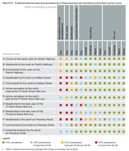
What type of 24 hr work might pose a nuisance?
There will be a variety of work carried out on the site. In attempt to ameliorate the impact of these works a large Acoustic Shed will be constructed. See table for assessed noise impacts.
Temporary re-location of the 575 bus stop on Pacific Highway (between Bryson and Mowbray Rds)
We understand this will be determined later in the project.
Q: Where exactly will the excavation start for the inclined ramp down to the “dive”? – at the existing train parking bay located between the inbound & outbound tracks
Roughly between Hopetoun and Chapman Avenues.
Q: Will the rail corridor be widened north of Nelson St. If so, how wide?
No. All new works are within the existing rail corridor.
Traffic
Has a traffic study been undertaking on the impact. What was the outcome?
Yes. See below.
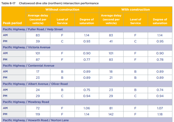
The above table summarises the project impact of the development on traffic in the area. The biggest predicted impact id at the intersection of the Pacific Highway and Mowbray Road, particularly in the afternoon peak.
What is the destination for spoil?
We understand that the specific location of the spoil sites will not be known until after the project has commenced. We also understand that it is standard planning practice to remove spoil by the closest arterial road (in this case the Pacific Highway).
Could an alternate haul rout be considered that does not require trucks to cross Mowbray Rd?
Whilst such an option could be considered it is contrary to the practice of taking spoil out by the closest arterial road.
